DESCRIPTION
South Westminster Transit Oriented Development [TOD] is a 100 acre redevelopment of an existing industrial neighborhood into a vibrant, mixed use neighborhood. The existing site [which required significant environmental remediation] is located adjacent to the Boulder/ Denver commuter rail tracks and was selected as the […]
DESCRIPTION
VMWP is the urban design and architectural consultant for the Environmental Protection Agency’s Smart Growth Technical Assistance Program Team. The EPA Technical Assistance Program provides grants in the form of technical assistance from economic urban design and traffic and circulation specialists to communities faced with […]
DESCRIPTION
The Smart Growth Strategy Place Types model was part of a regional planning effort intended to achieve support among public officials, civic leaders, and stakeholder organizations for a preferred land use pattern informing how the Bay Area could grow over the next 20 years. The […]
DESCRIPTION
VMWP is collaborating with Raimi + Associates on overhauling the zoning and regulatory structure of Mountain View to allow the construction of up to 10,000 housing units in a mixed-use neighborhood in the North Bayshore area. VMWP is spearheading the urban design, block structure, street […]
DESCRIPTION
VMWP’s work on the East Palo Alto General Plan includes urban design and housing direction and the development of the Westside Community Plan for the area of East Palo Alto west of US-101. The Urban Design chapter of the General Plan will focus on strengthening […]
DESCRIPTION
The South San Francisco Transit Village Plan encompasses 50 acres of existing neighborhoods and new development parcels within about 1/2 mile of the new South San Francisco BART Station. The plan was developed during a 6-month process in collaboration with a Technical Advisory Committee, Planning […]
DESCRIPTION
The City of San Leandro is embarking on the creation of a Bay Fair TOD Specific Plan to create a vision, policies, standards, and implementation strategies for the future of the Bay Fair area. The project area spans both the City of San Leandro and […]
DESCRIPTION
The Visitacion Valley/Schlage Lock Master Plan redevelops the 20- acre brownfield site into a vibrant mixed-use and transit-oriented neighborhood. The project is at the southern edge of San Francisco and the northern end of the future Baylands development. The new neighborhood extends the city grid […]
DESCRIPTION
VMWP has provided urban design expertise to the Precise Plan process for 3.9 miles of El Camino Real in Mountain View. The analysis and design guidelines build the framework necessary to reposition ECR from a typical low-density suburban arterial into a ‘Grand, multi-modal, mixed-use Boulevard […]
DESCRIPTION
The Grand Boulevard Initiative is the coordinated planning effort of multiple Cities, Counties and agencies to develop a Vision for approximately 50 miles of the El Camino Real corridor into a series of vibrant mixed use hubs. VMWP worked closely with Strategic Economics, the prime […]
 South Westminster Station TOD
 EPA Smart Growth Charettes
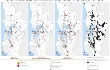 ABAG Smart Growth
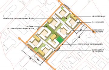 North Bayshore Precise Plan
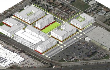 East Palo Alto General Plan
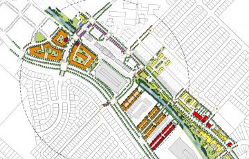 South San Francisco Transit Village
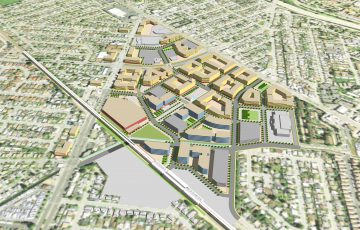 Bay Fair TOD Specific Plan
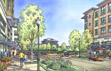 Schlage Lock Master Plan
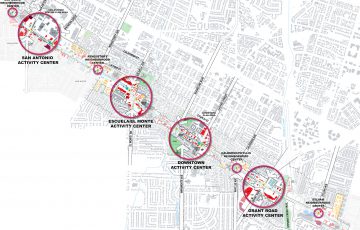 El Camino Real Precise Plan
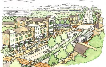 Grand Boulevard Feasibility Study