description
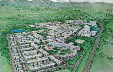
Superior New Town Center is a 162 acre parcel of vacant land on the Highway 36 Denver-Boulder Corridor. Superior Original Town is just west of McCaslin Blvd., which borders the western edge of the site. Coal Creek and Coal Creek Regional Trail run through the […]
description
The Pleasanton TOD Standards and Guidelines, put together with TransACT for the City of Pleasanton and BART, creates overlay zones for three parcels in the Hacienda Business Park PUD and the BART parcel to allow for the incremental development of a TOD village around the […]
DESCRIPTION
The Westminster mall sits at the crossroads of US 36, Sheridan Street and 88th Avenue, adjacent to a planned Regional Transportation District multimodal commuter rail stop. The plan for this new urban neighborhood is organized by a traditional pedestrian-oriented street grid surrounding a central Town […]
DESCRIPTION
The MacArthur Boulevard Conceptual Commercial Revitalization Plan provides urban design recommendations to improve the physical appearance of three target areas along MacArthur Boulevard, between 73rd Avenue and Durant Avenue at the Oakland/San Leandro border. Design concepts were developed and refined through a community process that […]
DESCRIPTION The MacArthur Transit village site is approximately seven acres and is presently used as a surface parking lot containing approximately 600 parking spaces. The goal of the development is to create a transit-oriented, housing-focused, mixed-use development, which functions both as a focal point and an […]
DESCRIPTION
The South San Francisco Transit Village Plan encompasses 50 acres of existing neighborhoods and new development parcels within about 1/2 mile of the new South San Francisco BART Station. The plan was developed during a 6-month process in collaboration with a Technical Advisory Committee, Planning […]
description
The East Kapolei Neighborhood TOD Plan presents a unique opportunity to create a sustainable, responsible and integrated community for Oahu. Located along the proposed transit line that will connect downtown Honolulu with the East Kapolei region, Ho’opili, UHWO and East Kapolei Stations are each envisioned […]
DESCRIPTION
55 Laguna is an urban infill, mixed income, mixed-use development that compliments the physical characteristics of the surrounding neighborhood, while adhering to the desires of the local community and San Francisco’s Better Neighborhoods Market and Octavia Plan. The formerly vacant UC Extension Campus will be […]
DESCRIPTION
Belle Terre is a 46-unit development of new affordable senior rental housing in downtown Lafayette. The development includes one building with a two-story element along Mt. Diablo Boulevard that steps up to three-stories. A gracious front porch wraps around the building’s Mt. Diablo frontage and […]
DESCRIPTION
Beginning in spring of 2015, VMWP and the PSR Consolidation Committee have been meeting regularly to establish the programatic needs of the school, and the best way to physically integrate their academic and support functions under one roof. VMWP has been instrumental in collecting stakeholder […]
 Superior New Town Center
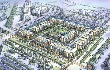 Pleasanton BART Transit Village
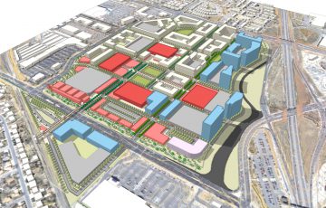 Westminster Mall
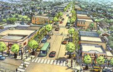 MacArthur Streetscape
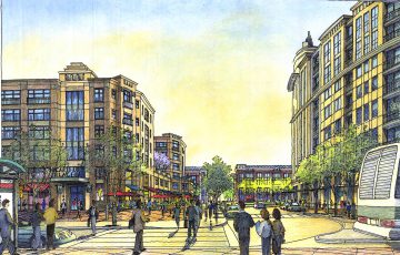 MacArthur BART Masterplan
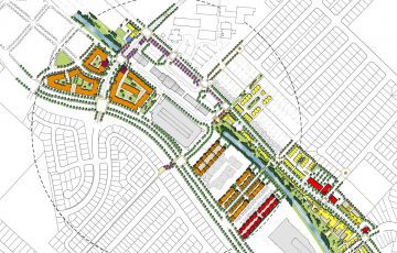 South San Francisco Transit Village
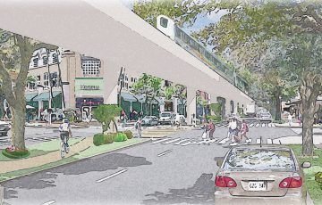 East Kapolei Neighborhood TOD Plan
 55 Laguna Street
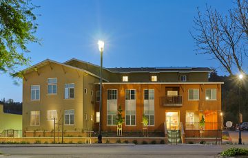 Belle Terre Senior Housing
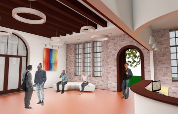 Pacific School of Religion